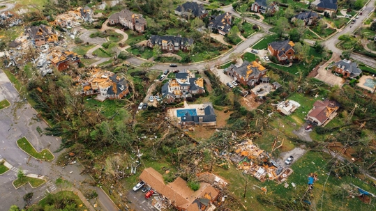
Some experts say that meteorologists’ tools to forecast Hurricane Ian’s path were part of the problem. The storm was very difficult to predict, and it caused a lot of damage.
This article is important because it discusses the death toll and damage caused by Hurricane Irma in Ft. Myers, Florida. It also asks how emergency managers could have better clarified the storm would devastate the area. This is important because it can help improve how emergency managers handle future storms and help to save lives.
The story of Hurricane Ian is about how people underestimated the storm’s strength and how it surprised so many people. The storm was originally thought to be heading toward Florida, but it ended up veering off to the south and affecting many people who were not expecting it. This story highlights the importance of understanding how storms work and interpreting their information.
What Made Hurricane Ian a Complex Hurricane Forecast?
Forecasters were unsure which model to believe until about 36 hours before Hurricane Irma made landfall in Florida. This left coastal residents with little time to evacuate.
The main American forecast model—the Global Forecast System (GFS)—showed for several days that the storm would most likely hit the Florida Panhandle or Big Bend area as a Category 2 storm.
The European model for the storm was more accurate than the American model, predicting a stronger and more southern storm track. The European model did not waver in its predictions, while the American model changed its predictions frequently.
The Survivor’s Accounts
Residents in Lee County, which was hit hard by the storm, say they thought the hurricane was heading to Tampa based on previous forecasts.
The NHC predicted that the hurricane would follow a path between the two models, but they were unsure of its exact path. They urged people to pay attention to more than just the center of the hurricane’s path, as there was a lot of uncertainty surrounding the storm.
NHC forecasters also reminded users not to focus on the storm’s exact track as additional adjustments might have been made. They also cautioned that wind, storm surge, and rainfall hazards would extend far from the storm’s center. This means that even though the center of the hurricane may not hit a certain area, the hurricane could still cause major damage to that area.
A Misunderstanding of Data
The cone of uncertainty is a common graphic used to depict the amount of uncertainty in a forecast. It is often used in weather forecasts but also in other forecasts, such as economic forecasts. The cone of uncertainty graphic is often misunderstood, with people thinking that it means that the forecast is only 20 percent certain. The 20 percent figure refers to the amount of uncertainty in the forecast, not the level of certainty. The cone of uncertainty is a valuable tool for understanding the amount of uncertainty in a forecast.
There is a two-thirds likelihood that you will see a direct hit from a landfalling storm if you are in the cone, but this does not mean that areas outside the cone will be unscathed. This means that, based on the data available, it is highly likely (two-thirds) that the hurricane will make landfall. The location of landfall has not been determined with certainty, but it is still within the originally predicted area.
Conclusion
It is important to be aware of hurricanes’ dangers to coastal areas. Hurricane Ian was a particularly destructive storm, causing significant damage to buildings and infrastructure. However, the efforts of emergency responders worked to minimize the damage as much as possible.
Get emergency disaster cleanup and water damage restoration services in Naples with DryZone! We offer water removal, mold remediation, fire damage cleanup, and other restoration services. You can rely on DryZone to respond immediately. Our team specializes in structural drying—quickly returning the structure back to its pre-loss condition. Contact us today for immediate assistance!


